
The Enigmatic Fortress near Rosh HaAyin: Antipatris Revealed!
Explore intriguing historical ruins, picnic groves, and kid-friendly attractions. Join tour guide Osher Nadivi on a journey through Tel Afek National Park.
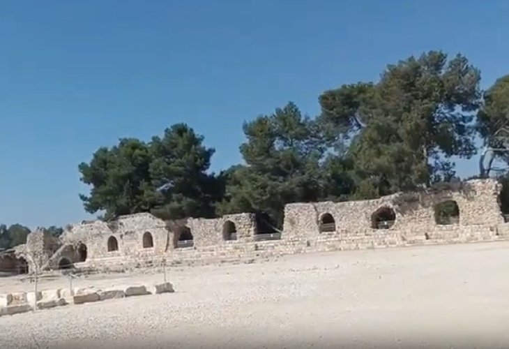
Traveling along Highway 483 from Petah Tikva to Rosh HaAyin, you cannot miss the striking remnants of a fortress near the road to the north. Behind its walls lie many secrets waiting to be unveiled.
Why was a settlement established here in the first place? There are two primary historical reasons: security and water. This strategic location secured the ancient international route from Egypt to Mesopotamia. Additionally, the area's abundant springs were a precious resource, making it a natural choice for establishing a settlement.
Historical Sources and Findings
The settlement of Antipatris appears multiple times in historical texts.
In the Midrash Bereshit Rabbah, Parashat Chayei Sarah, it says, "Rabbi Akiva had 12,000 pairs of students from Gevat to Antipatris, all of whom died in one period because they were envious of one another."
The Talmud (Niddah 62a), in a discussion about stain removing materials, mentions niter from Antipatris as somewhat effective: "It was taught: Alexandrian niter, not Antipatris niter."
The Talmudic Encyclopedia (Volume 27) refers to Antipatris as a place inhabited by idol worshippers based on ancient sources: "The village dome, the Antipatris dome, and Peter's market—places where Cutheans lived."
Rabbi Yissachar Tamar, in his commentary "Ali Tamar" on the Jerusalem Talmud, Tractate Berachot, cites Midrash Mishlei: "When Rabbi Akiva was executed in prison, they took him until they reached Antipatris of the reapers. When they arrived, a cave opened before them with a chair, bench, table, and lamp. They laid Rabbi Akiva on the bed and left. When they left, the cave closed, etc." There are various speculations about where "Antipatris of the reapers" was located. Some believe it was the Antipathos fortress near Petah Tikva, supporting the theory that due to persecution by the authorities, they decided to bury Rabbi Akiva's ark there instead of in Bnei Brak, his hometown.
Findings in the Area
Researchers have uncovered findings from ancient times, including bullae (seals) from when the Egyptian kingdom ruled the area over five thousand years ago, artifacts from the Hellenistic period when it was called Pagani (meaning springs, preserved in the name of the nearby village Pag'a until the War of Independence), and extensive remains from the Roman period when the settlement was called Antipatris, including remains of the cardo (the main street), column remnants, and a small odeon (a public building for musical performances).
Building the Wall
When the Ottomans conquered the Land of Israel in the 16th century, they constructed the large fortress with its impressive walls, naming it Bin-bash (translated freely from Turkish as "head of the springs") due to the many nearby springs. The fortress was built using locally quarried stones and many stones from the area. Therefore, the Ottoman wall features Herodian-style carved stones, parts of round columns, and fieldstones bonded with clay.
Water to Jerusalem...
After World War I and the collapse of the Ottoman Empire, the British took control of the region and built a military camp between the fortress walls. Nearby, they constructed another camp for the Royal Air Force near Kfar Sirkin, which included an airport that was used until recently. Realizing the need for running water in Jerusalem, which relied on well water until then, they decided to pump spring water and pipe it towards Shaar HaGai, from where it would be pumped to Jerusalem.
As the British prepared to withdraw in 1948, Hassan Salameh's gang, reinforced by Iraqi forces, took control of the site. During Operation Tin in the War of Independence, Irgun and Alexandroni Brigade forces liberated the area after fierce battles. The retreating Iraqi forces attempted to blow up the water pumps, but Jewish forces managed to prevent it.
From the 1950s, after the area was annexed to Petah Tikva, there were attempts to establish a national park. Since the 1970s, the site has been accessible to visitors.
Why Visit?
Today, you can explore the extensive archaeological excavations conducted at the site over the years, wander between the fortress walls, and walk along the restored cardo as the citizens did 2,000 years ago.
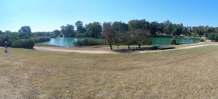
There's a large, shaded picnic grove at the site, and if you arrive early enough, you might enjoy a view of the lake—though with no shade...
The site's main attraction for young children is several wading pools about 40 cm deep. A 200-meter-long stream flows between them, offering a real water adventure for kids and their parents. Supervision of children in the water is mandatory!
More Information...
Entrance to Tel Afek National Park is located between Rosh HaAyin and Petah Tikva on Highway 483, east of the Ganot Junction. You can reach the site by public transport or car, with abundant parking available.
Entry is fee-based.
Entrance hours: 08:00 AM to 5:00 PM. In summer, visit times might be extended to 6:00 PM; keep an eye on announcements.
Osher Nadivi is a certified tour guide. For feedback/questions: editor.nelech@gmail.com
